Professor John Graves - Satellite Tagging Research - 6 Reports
08/28/08 - John Tierney/John Graves - Virgin Islands Tagging Report
Attached is an email and map attachment showing the prelim results of Dr. John Graves pop up sat tags results from Aug. fishing in St. Thomas.Bob DeGabrielle, John Graves and I fished 5 days and released 11 blue marlin aboard Tough Catch and placed 7 pop up sat tags in blue marlin...1 on the North Drop at and 6 at Anageada.All 7 survived and the tags all popped up in 10 days.Fish were released on both circle hooks and J hooks. One was bleeding prior to release and the tag placement on that fish was terrible, below the lateral line.
I think its very interesting that all 7 traveled mostly south and east!The red dot is where the tag was floating at the time Dr. Graves received the data and the start of the trail is where the tag popped up.More data will come from Dr. Graves soon.
We will try again on the Sept. moon to place 10 more pop up tags. Dr. Graves research is wonderful and we should all thank his efforts. The tags cost $3,000 each. See his article in one of the spring 2008 edition of Marlin for info on his research on white marlin.
Tight lines...John Tierney
On Mon, 8/25/08, John Graves wrote:
John:
I'm finally back in the office. I was up in Cape May, NJ last week for the
Mid-Atlantic $500,000 all of last week. I've been the tournament's
"biologist" since it started in the early '90s. Fishing was
good, with
boats averaging more than 1.0 white marlin per day, with a few blue marlin
in the mix as well. Only three blues were brought to the weigh station:
719, 625, and 501, so I guess they didn't do too much damage to the
spawning stock. Add the first and third fish together and you have the
Pirate's Cove beast. A total of 31 "white marlin" were weighed
in. Three
of those were roundscale spearfish, and one may have been a longbill
spearfish. That fish came into the Ocean City, MD weigh station and my
former student wasn't sure as he had never seen a longbill spearfish. It
had a vent far in advance of the anal fin, but based on the lower jaw -
fork length (75 inches) and weight (62 lb), it was longer and skinnier than
any roundscale spearfish I've seen. I'll know for sure after we do the
genetics this week.
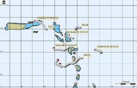
After returning home from the tournament I jumped on the computer to see
what happened to the seven blue marlin we released off St. Thomas as the
tags should have been popping up during the week. All seven tags are up
and transmitting, and all seven blue marlin appear to have survived. I'm
attaching a map showing the location of the seven tags. The red dot is the
current location of the drifting/transmitting tag, and the trail of white
dots shows previous positions. Just follow the line to the first dot and
that was the pop-up location. All of the fish moved out of the area, but
there doesn't seem to be a trend in where they went. Even the fish that
was bleeding (and tagged fairly low) did fine. The tags will continue to
transmit the archived data for another three weeks before their batteries
are spent, and over that time period we should receive ~85% of the archived
data (depth, temperature and light level every 90 sec.).
I'll send ten more tags to Bob for your September trip to St. Thomas. The
tagging pole is already on the boat. If you deploy all of them I'll be
more than happy to send another batch down before your trip to Venezuela.
Cheers,
John
John Graves
Professor of Marine Science
Virginia Institute of Marine Science
College of William and Mary
P.O. Box 1346 (mail);
Route 1208 Greate Road (FedEx, UPS)
Gloucester Point, VA 23062
804 684-7352 (office); -7258 (lab); -7157 (fax)
09/19/08 - John Tierney/John Graves - Virgin Islands Tagging Report
Jimmy, here is the info from the 1st 5 released with pop up tags on the Sept. moon fishing. We have 5 more to go and will send info on them when available. JT
From: John Graves
Subject: #5 is up
Date: Thursday, September 18, 2008, 11:30 AM
Bob and John:
The fifth tag popped up this morning. Unlike the others, this fish went
west and appears to be in the Mona passage. Map attached.
Cheers,
John
John Graves
Professor of Marine Science
Virginia Institute of Marine Science
College of William and Mary
P.O. Box 1346 (mail);
Route 1208 Greate Road (FedEx, UPS)
Gloucester Point, VA 23062
804 684-7352 (office); -7258 (lab); -7157 (fax)
09/19/08 - John Tierney/John Graves - Virgin Islands Tagging Report
Bob and John:
You tagged two small (~90 lb) blue marlin on September 10th. The first fish (tag #6) required resuscitation and the second (tag #7) did not. Tag
#7 popped up this morning, and like a previous fish, it moved north. I'm attaching a map. The map provides the positions for the past four days so you can get a feel for the currents (the red spot is the most recent location, so tags that were up earlier have a longer trail of white dots (former positions). Tag #6 hasn't reported yet, but that's not unusual. If it isn't up by tomorrow, then we can start speculating what might have happened. For the animals that we tagged in the past that have been scavenged or predated on by sharks, their tags often pop up a few to several days late. That's because the tag pops off inside the shark's stomach, but it cant surface until the shark regurgitates.
Cheers,
John
John Graves
Professor of Marine Science
Virginia Institute of Marine Science
College of William and Mary
P.O. Box 1346 (mail);
Route 1208 Greate Road (FedEx, UPS)
Gloucester Point, VA 23062
804 684-7352 (office); -7258 (lab); -7157 (fax)
09/22/08 - John Tierney/John Graves - Virgin Islands Tagging Report
Bob and John:
All nine tags that you put out are up. The last tag popped up down island (it's the one with the shortest "tail" in the attached map). Note that the prevailing currents are moving the tags to the northwest. The two tags that popped up off Anegada are problematic. You know that one was a fish that was eaten by sharks and the other was the small blue marlin that required resuscitation (and could have been a victim of predation). If the tags had been floating, one would have expected them to move to the northwest. If they had been ingested by a shark, one wouldn't expect them to pop-up on schedule. Hmmm. In any case, I should have enough data (temperature, pressure and light level) later this week to figure out what happened.
Cheers,
John
John Graves
Professor of Marine Science
Virginia Institute of Marine Science
College of William and Mary
P.O. Box 1346 (mail);
Route 1208 Greate Road (FedEx, UPS)
Gloucester Point, VA 23062
804 684-7352 (office); -7258 (lab); -7157 (fax)
09/24/08 - John Tierney/John Graves - Virgin Islands Tagging Report
Bob and John:
I was able to look over the incoming data from the three "questionable"
fish that you released off St. Thomas a few weeks ago. During the first few days of transmission, we generally get 6-8% of the archived data per day. After that recovery rates fall off as some of the messages are duplilcates of data packets already received. When the batteries finally die after about 30 days, we usually have 70 - 90% of the data. Still, after three or four days with ~25% of the 9,000 data points, we can make some inferences regarding survival.
The only fish that died was the one that was eaten by sharks, and from the sound of it, it wouldn't have made it with or without sharks. The tag was consumed minutes after deployment, as the light level went to zero
(darkness) and stayed that way for ten days. The shark conveniently regurgitated the tag just as it was "popping up" (running a current through the wire that attaches the tag to the tether) so it floated up to the surface right on time and started transmitting. In the past, most of our predated or scavenged tags have reported after the due date as they were in the bellies of sharks, and we won't receive transmissions unless they are at the surface (we have to wit for the sharks to spit them out). From the tag data, the shark exhibited a different depth profile than the blue marlin. It didn't spend any time at the surface, staying between 100-200m.
The fish with the serious eye injury survived. It spent most of its time near the surface with sporadic diving between 75-100m (and the tag noted day/night light level differences, so it wasn't in another animal's stomach!). For some reason, this fish spent the entire day of 14 September
(6 days after release) at the surface.
The small (~90 lb) fish that required resuscitation made it as well. Its diving pattern was pretty typical for blue marlin, lots of time near the surface with lots of dives in the 100 - 150m range.
Thanks for all of your help.
Cheers,
John
John Graves
Professor of Marine Science
Virginia Institute of Marine Science
College of William and Mary
P.O. Box 1346 (mail);
Route 1208 Greate Road (FedEx, UPS)
Gloucester Point, VA 23062
804 684-7352 (office); -7258 (lab); -7157 (fax)
09/25/08 - John Tierney/John Graves - Virgin Islands Tagging Report
Bob and John:
The tenth tag popped up on schedule this morning. The fish went pretty much due north, the same as two others (see attached map). Please send me the data sheet when it's available.
Not counting the one fish that didn't make it as a result of the tagging process, we have 16 fish from St. Thomas, 12 on Ilander or Chugger/J hooks and 4 on circle hooks. No mortalities. It would be nice to get a few more circle hook fish tagged off St. Thomas, but as we didn't have any mortalities, there really isn't a problem with a potential bias due to shark predation. Clearly, the results with blue marlin are a lot different than white marlin.
Many thanks for all of your help.
Cheers,
John
John Graves
Professor of Marine Science
Virginia Institute of Marine Science
College of William and Mary
P.O. Box 1346 (mail);
Route 1208 Greate Road (FedEx, UPS)
Gloucester Point, VA 23062
804 684-7352 (office); -7258 (lab); -7157 (fax)

 After returning home from the tournament I jumped on the computer to see
what happened to the seven blue marlin we released off St. Thomas as the
tags should have been popping up during the week. All seven tags are up
and transmitting, and all seven blue marlin appear to have survived. I'm
attaching a map showing the location of the seven tags. The red dot is the
current location of the drifting/transmitting tag, and the trail of white
dots shows previous positions. Just follow the line to the first dot and
that was the pop-up location. All of the fish moved out of the area, but
there doesn't seem to be a trend in where they went. Even the fish that
was bleeding (and tagged fairly low) did fine. The tags will continue to
transmit the archived data for another three weeks before their batteries
are spent, and over that time period we should receive ~85% of the archived
data (depth, temperature and light level every 90 sec.).
After returning home from the tournament I jumped on the computer to see
what happened to the seven blue marlin we released off St. Thomas as the
tags should have been popping up during the week. All seven tags are up
and transmitting, and all seven blue marlin appear to have survived. I'm
attaching a map showing the location of the seven tags. The red dot is the
current location of the drifting/transmitting tag, and the trail of white
dots shows previous positions. Just follow the line to the first dot and
that was the pop-up location. All of the fish moved out of the area, but
there doesn't seem to be a trend in where they went. Even the fish that
was bleeding (and tagged fairly low) did fine. The tags will continue to
transmit the archived data for another three weeks before their batteries
are spent, and over that time period we should receive ~85% of the archived
data (depth, temperature and light level every 90 sec.).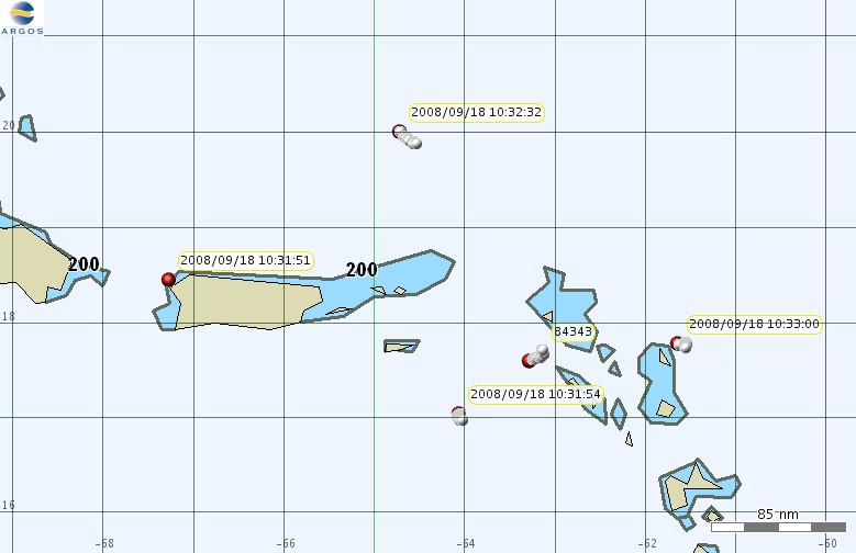 Bob and John:
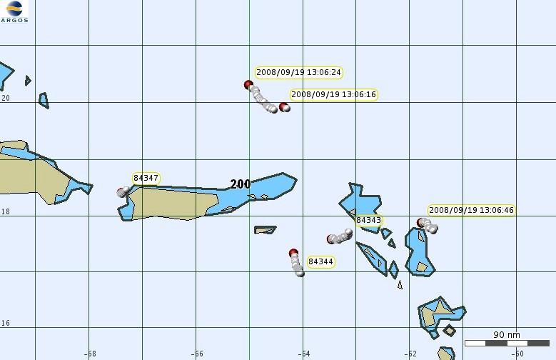 You tagged two small (~90 lb) blue marlin on September 10th. The first fish (tag #6) required resuscitation and the second (tag #7) did not. Tag
#7 popped up this morning, and like a previous fish, it moved north. I'm attaching a map. The map provides the positions for the past four days so you can get a feel for the currents (the red spot is the most recent location, so tags that were up earlier have a longer trail of white dots (former positions). Tag #6 hasn't reported yet, but that's not unusual. If it isn't up by tomorrow, then we can start speculating what might have happened. For the animals that we tagged in the past that have been scavenged or predated on by sharks, their tags often pop up a few to several days late. That's because the tag pops off inside the shark's stomach, but it cant surface until the shark regurgitates.
You tagged two small (~90 lb) blue marlin on September 10th. The first fish (tag #6) required resuscitation and the second (tag #7) did not. Tag
#7 popped up this morning, and like a previous fish, it moved north. I'm attaching a map. The map provides the positions for the past four days so you can get a feel for the currents (the red spot is the most recent location, so tags that were up earlier have a longer trail of white dots (former positions). Tag #6 hasn't reported yet, but that's not unusual. If it isn't up by tomorrow, then we can start speculating what might have happened. For the animals that we tagged in the past that have been scavenged or predated on by sharks, their tags often pop up a few to several days late. That's because the tag pops off inside the shark's stomach, but it cant surface until the shark regurgitates.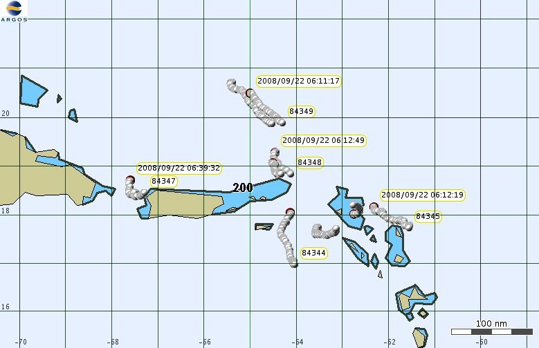
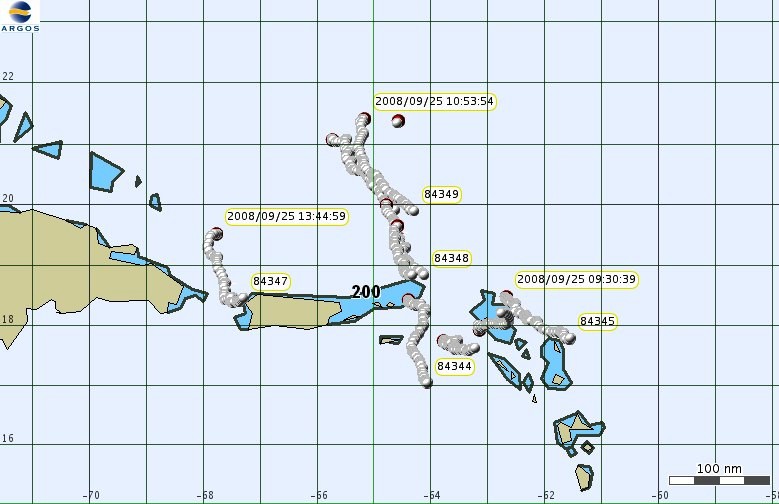 The tenth tag popped up on schedule this morning. The fish went pretty much due north, the same as two others (see attached map). Please send me the data sheet when it's available.